Turn a GPX file into a video
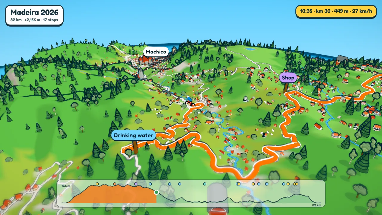
A GPX file is a list of points: where you were, how high, and usually when. ToonRoute reads those points, builds the country around them as a cartoon world, and films a character going round your route. You get back an MP4 you can post anywhere.
This page goes through it from the file to the finished video. It works the same for a ride, a walk, a run, a drive or a flight, and for FIT files as well as GPX.
Getting the file
Most apps will give you a GPX file of an activity or a planned route. Where the menus are changes now and then, but roughly:
- Strava: open the activity, press the three dots and choose Export GPX.
- Garmin Connect: open the activity, press the cog and choose Export to GPX. Export Original gives you the FIT file, which works too.
- Komoot: on a tour or a planned route, the download option gives a GPX file.
- RideWithGPS, Wahoo, PitStopper: all export GPX or FIT, and both work.
No file at all? Use Create a route and pick a start, an end and any stops on a map. The route follows roads and paths the character can use.
What ToonRoute uses from the file
The track points draw the route. Their heights find the climbs and make the elevation chart. If the points have times, the character can ride at your real speed and the light can follow the real time of day (the ride's clock). Waypoints become signposts, and a FIT course's points do the same, except the turn directions. A file with no times is fine: the character just rides at an average speed.
Step by step
- Open the app and choose Use my route file. Pick the GPX or FIT file. ToonRoute fetches the terrain and map for the area and builds the world in your browser, which takes longer for a long route.
- Watch the preview. It plays straight away with the defaults: sunny, a cyclist, the Auto camera. Everything you change from here shows up in it.
- Choose a look and a character in the Landscape and Character settings. Six looks, rain or snow if you like, and a walker, car, kayak, plane, helicopter or a few sillier things instead of the bike.
- Check the signs. Open Sign posts to rename a stop, change its type or colour, or take it out. To add one, pause where the character is at the spot and press Add sign post here.
- Set the length. Auto gives about 1.6 seconds a kilometre, between one and six minutes. Or pick 45 seconds, a minute and so on, in Video.
- Make the video. Choose 16:9 or 9:16, then 720p, 1080p or 4K. Our server makes it from exactly these settings while you watch, and you download it from the page. Give an email address if you want the link sent too.

Tips
- A recorded file with a long café stop has the stop in it, as a gap in the times. With speed set to As recorded, that gap is kept short so the video does not stand still.
- Lots of waypoints make a slow video, because the character pauses at each one. Take out the ones that do not matter, or turn off Pause at stops in Track.
- Save the route as a project before you close the tab. It keeps the world and every setting, so you do not wait for the build again.
- A day's route can be up to about 200 km across. A tour of 2 to 10 days can be one video in chapters (Whole tour in the Days list), or one video a day.
Questions
Which files work?
GPX and FIT, which covers the exports from Strava, Garmin Connect, Komoot, RideWithGPS, Wahoo and PitStopper. KML and KMZ from Google Earth, GeoJSON, and a drone's SRT flight log work too. TCX is not read yet, so convert it to GPX first.
Do I need an account?
No, and not even an email address: you download the video from the page. Give one only if you want the link emailed. Projects are saved in your own browser.
What happens to my route?
The world is built in your browser. When you order a video, the route and settings go to our render server to make it. The route is deleted once the video is made, and the video an hour after you download it, or after seven days.
Can I use a route I have not ridden yet?
Yes. A planned route has no times, so the character goes at an average speed for the kind of trip. It is a good way to show a group what a ride or walk looks like before the day.
Is it free?
During the beta, yes: one at a time and up to six a day, at any size. After the beta a video will cost a small amount. The pricing page has the details.
Use my route file Create a route
Other guides
- A fly-through of your bike ride
- A video of your hike or walk
- A running route video
- Tall videos for Reels and TikTok
- A flight path animation
- A route video for your event
- A cartoon video of your road trip
- A Tour de France stage as a cartoon
- A fly-through of a famous climb
- From a Strava activity to a video
- ToonRoute and Relive compared
- Everything ToonRoute does