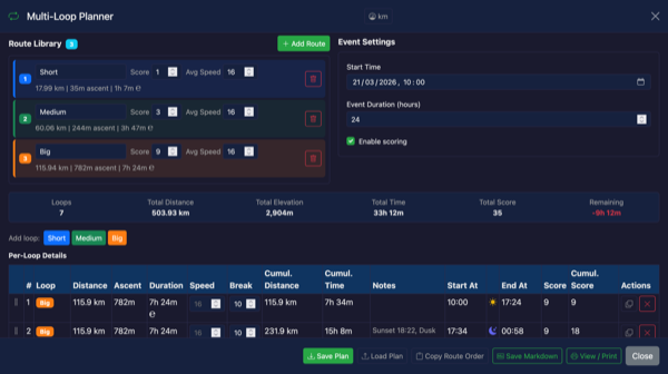
Plan Multi-Loop Endurance Events with the Multi-Loop Planner
Recent Projects
Welcome to PitStopper. We'll help you to discover a wide variety of waypoints along your planned route or a specific location. You can find cafes, water points, camping sites and a whole lot more. There are many features to narrow down your search and you can add custom waypoints. You are then able to download a new GPX or FIT file for your bike computer or print waypoint sheets and event stickers.
Create Your Route
Plan your travel route in your favorite route planning app
- Strava
- RideWithGPS
- Garmin Connect
- Any GPX or FIT compatible app
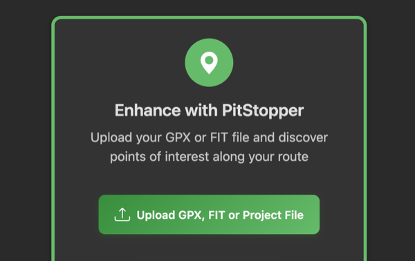
Enhance with PitStopper
Upload your GPX or FIT file and discover points of interest along your route
Use Your Enhanced Route
Load the enhanced GPX or FIT file into your GPS device or print a detailed report
- Load to GPS device
- Print report
- View waypoints
- Navigate with confidence
Try PitStopper with a Real Route
Don't have a GPX or FIT file? Load one of our demo routes to explore PitStopper's features. Search for POIs, add waypoints, and see how it all works!
PitStopper Activity
(since Jan 17, 2026)
POIs Discovered
Waypoints found by users
Kilometers Analyzed
Routes processed
60+
POI Categories
Water, food, camping & more
Find water sources, gas stations & refill points
Discover restaurants, cafes & food stops
Locate accommodations & camping sites
View elevation profiles & route details
Printable POI list with comprehensive details
Custom Event Sticker Generator for bike frames
Immersive 3D terrain visualization of your route
Add custom POI types: Info, Warning, Danger
Multi-route support for multi-day adventures
Detect tunnels, steep sections & road hazards
Search for Wikipedia photos & articles along a route
Latest from the Blog

February 2026 Roundup - FIT Files, Weather, Fuel Prices & More
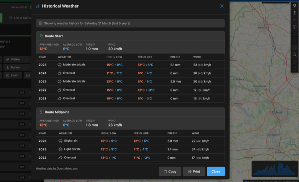
Historical Weather: Know What to Expect on Your Route
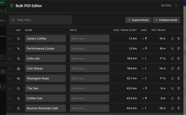
Bulk POI Editor - Edit All Your Waypoints at Once
Garmin FIT File Support - Import, Plan & Export
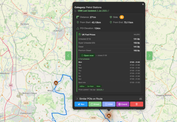
Fuel Prices & Opening Times Across Europe
Guides & Articles

How to Read a GPX File: A Complete Guide
GPX files are the universal language of outdoor navigation. Whether you've downloaded a route or exported one from an app, here's everything you need to know about what's inside a GPX file and how to use it.
Read
Chunking: Breaking Long Rides Into Manageable Blocks
Staring at a 300km ride can feel overwhelming. Chunking breaks it into 4-5 hour blocks, each with its own nutrition plan, gear, and goals. Here's how to use this strategy for your next ultra-distance event.
Read
I run this site for free and maintain it in my spare time. If you want to support what I do, my Ko-fi is always appreciated!