
You have loaded a route, searched for stops, and found it: a cafe right on the way. Except it is not quite on the way. It sits 200 metres down a side road, and your GPX line runs straight past the turning. Everything else about the route is perfect.
Until now, fixing that meant leaving PitStopper, re-opening the route in whatever planner drew it, dragging a waypoint, re-exporting, and re-loading. A lot of ceremony to reach one flat white.
Not any more. You can now edit the track directly on the map.
Drag the track, and it follows the road
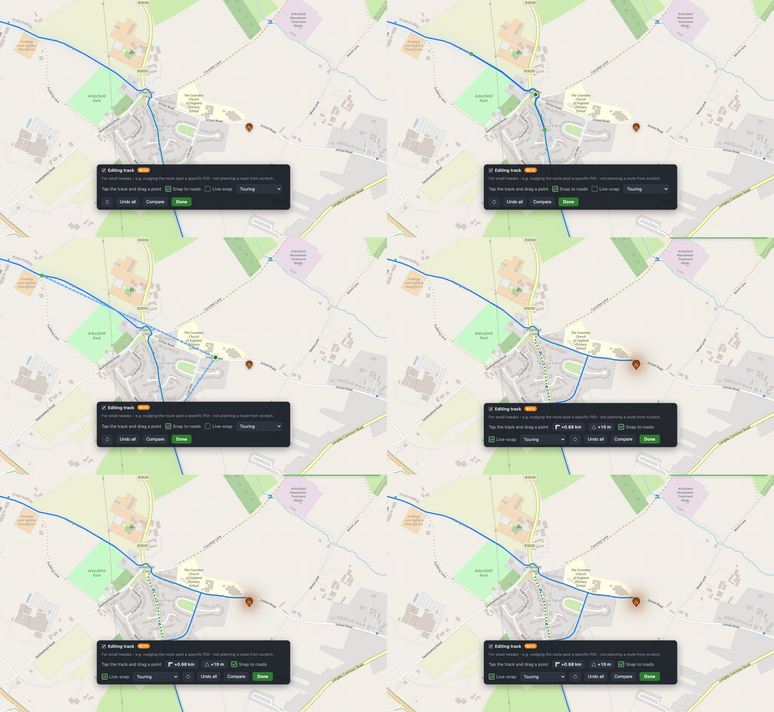
Tap the pencil button on the map (or Route menu -> Edit Track), zoom in, and drag any point of the track. PitStopper re-routes that stretch along real roads and paths, so the line bends the way a bike actually would - no dot-to-dot straight lines across gardens.

Here it is start to finish - grabbing the track at the crossroads and pulling it down School Road to reach the cafe:
The snapping is powered by BRouter, the open-source cycle router, running over OpenStreetMap data. You pick the road type it should prefer - Touring, Road bike, Road (low traffic), Gravel, Mountain bike or Walking - so a gravel detour and a road-bike detour take the sensible line for each. Prefer to place the line by hand? Turn Snap to roads off and drag freehand.
Everything updates as you go
An edit is never a leap of faith:
- Length and climb change, live. The toolbar shows the running difference since you started - "+0.68 km", "+10 m" - so you know exactly what the detour costs before you commit.
- The original stays visible. The bit you changed is kept as a dotted line, and a Compare toggle shows the whole original track alongside your edits.
- Elevation is recalculated automatically. The profile redraws, distance markers move, and every POI distance is re-measured against the new line.
- Undo, always. Step back one edit with Undo, or wipe a whole editing session with Undo all.
What it is for (and what it is not)
This is a tool for small tweaks - nudging the route past a specific POI, straightening a bit of GPS wander, taking the quieter parallel lane. It is deliberately not a from-scratch route planner. The banner says as much while you work, and the feature is marked Beta because we want your feedback on where it feels right and where it does not.
Try it and tell us
Load a route, zoom in, hit the pencil, and drag. If BRouter is briefly busy it falls back automatically, and nothing is saved until you are happy - so it is safe to experiment. Let us know how it works for the routes and surfaces you ride.
Map data (c) OpenStreetMap contributors. Routing by BRouter.


