A route rarely lives in one app. You might plan it in Komoot or Strava, look it over in PitStopper, then ride it with Locus Map, OsmAnd, Cruiser or a Garmin. Somewhere along that chain it usually loses something.
That's because GPX, the file format they all share, only covers the basics: the line you'll ride, the points along it, and a name for each. Everything else - the colour you gave the line, the icon on a café, the instruction to turn left at the junction - is an extra that each app adds in its own way. An app that doesn't recognise another app's extras skips them. Open the file somewhere else, save it again, and they're gone.
We think that's a waste, so PitStopper works the other way round. Any in, all out: read every app's extras when a file comes in, and when it leaves, write them all back out, in every app's own form at once.
Watch it on its own page, with the transcript
Any in

Routes reach us from two kinds of place. Online planners like Komoot, Strava and Ride with GPS export plain GPX: the line and your waypoints, without extras. Apps and devices like Garmin, Locus Map, OsmAnd, Cruiser and gpx.studio add their own.
When a file arrives, PitStopper keeps what it carries:
- A track keeps the colour, width and transparency it was given, whichever of the three common ways the app wrote them. A KML file's line style comes in too.
- Locus Map's own line settings, such as a line pattern, are kept.
- A track that arrives with turn-by-turn instructions, or with power and heart rate on every point, keeps them.
- Stops you import keep their own extras.

All of that becomes one picture of your route, and you can change it: the colour, width and transparency are in the route manager and in each route's own settings.
All out
When you export, PitStopper doesn't ask which app the file is for. It writes the same information in every form we know, side by side in one file, and each app reads the form it understands and skips the rest. The file is still valid GPX 1.1 - our tests check it against the official schema - so an app that only reads plain GPX opens it as normal.

What that means once the file reaches the next app:
- The line colour arrives as you set it in Locus Map, Cruiser, OsmAnd, Organic Maps, gpx.studio and GPX Viewer. A Garmin gets the nearest of its 16 colours, without the width.
- Turn-by-turn instructions, on a route planned in PitStopper or a track rebuilt on roads, are read by Cruiser and Locus Map.
- Stop icons travel three ways: a Garmin symbol name, which Garmin, Locus Map, Cruiser, gpx.studio and GPX Viewer draw from their own icon sets; OsmAnd's own icon name and marker shape; and, in a compressed .gpz file, PitStopper's own icons, which Locus Map and GPX Viewer draw.

Komoot and Strava read the route and the waypoints from that same file. They just don't show the extras.
Choosing what goes out
You don't have to change anything for your route's look and its stop icons to travel: the defaults already write them in every form. But if you want to see what's on offer, open Export → Export a file, choose GPX and open Advanced options.
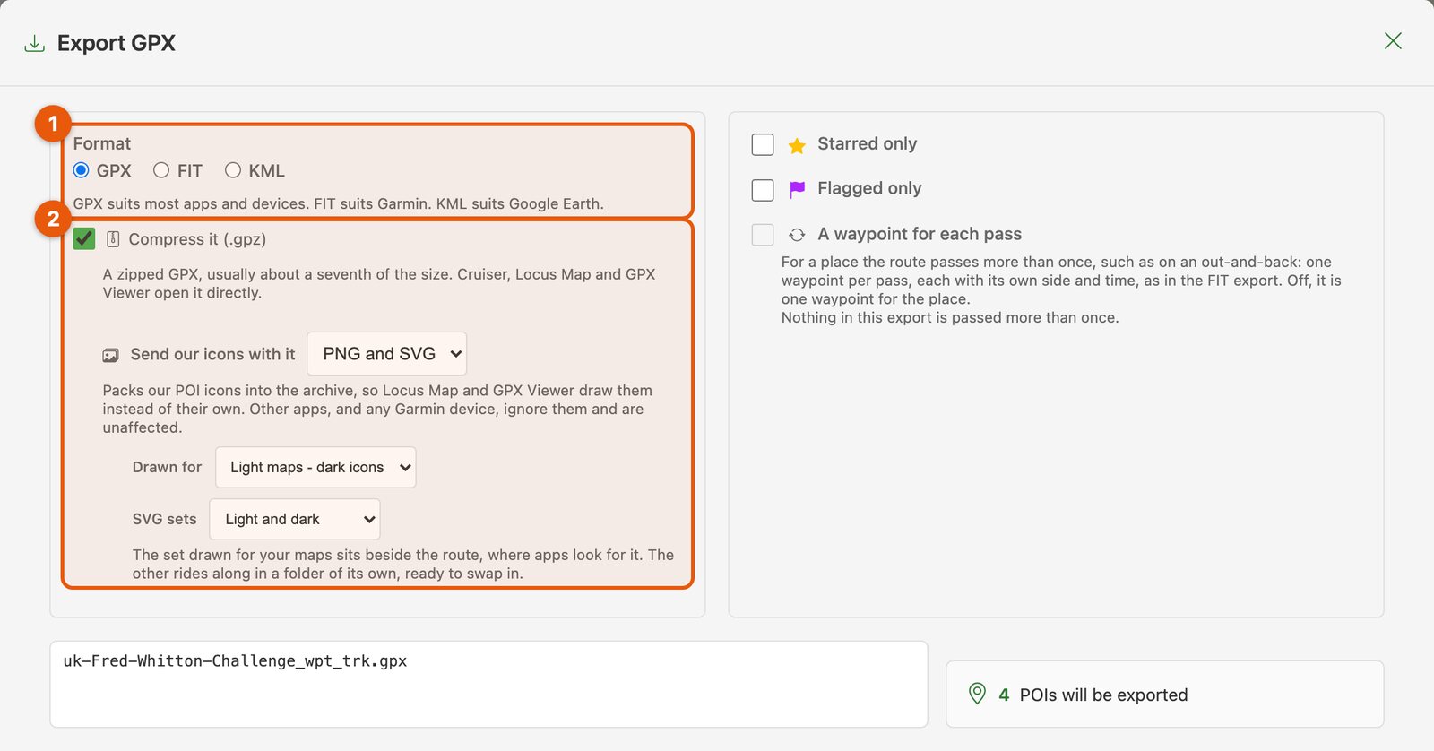
- Format. GPX suits most apps and devices, FIT suits Garmin and KML suits Google Earth. Everything below is for GPX.
- Compress it (.gpz). The same GPX, zipped to about a seventh of the size, which Cruiser, Locus Map and GPX Viewer open directly. Choose Send our icons with it and PitStopper's own stop icons travel inside the file, so Locus Map and GPX Viewer draw them instead of their own. You can pick icons drawn for light maps or dark ones. Every other app ignores them.
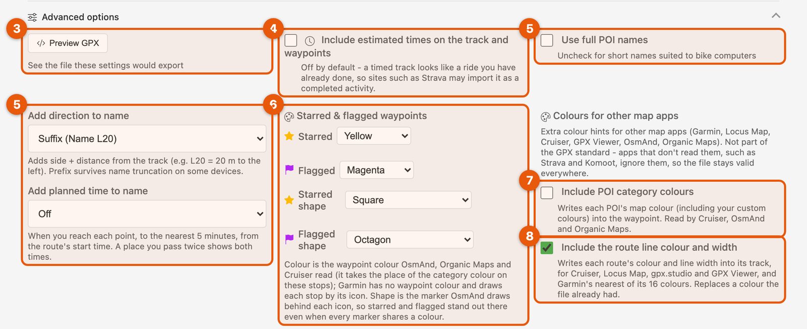
- Preview GPX. Shows you the file these settings would export, before you save it.
- Include estimated times. Off by default, because a track with times looks like a ride you've already done, and sites such as Strava may import it as a completed activity. Times need a start time for the route.
- Names. Full names, or short ones that fit a bike computer's screen. You can add which side of the road a stop is on and how far off the route ("Cafe L20" is 20 m to the left), and the time you should get there ("Cafe 15:15").
- Starred and flagged waypoints. The colour and marker shape for the stops you've marked. OsmAnd, Organic Maps and Cruiser read the colour, and the shape is the marker OsmAnd draws behind each icon, so your marked stops stand out there. A Garmin has no waypoint colour; it draws each stop by its icon.
- Include POI category colours. Off by default. Gives every stop its colour from PitStopper's map, your own custom colours included, for Cruiser, OsmAnd and Organic Maps.
- Include the route line colour and width. On by default. This is the one that writes the line's look in every form at once, for Cruiser, Locus Map, OsmAnd, Organic Maps, gpx.studio and GPX Viewer, and the nearest of 16 colours for a Garmin.
An aim, not a finished job
There are a lot of route apps, and they keep adding things. We read and write the extras we know about, checked against each app's own documentation or real files from people who use it, and we keep adding more. The full detail - every extra, where it sits in the file, which export option controls it and which apps read it - is on the help page: PitStopper GPX extensions.
To see what your own file carries, drop it into the GPX inspector and converter. It runs in your browser, lists every extra in the file and which app it comes from, flags anything we don't read yet, and writes the file back out with all of them. If it finds something new, it can copy a short report for you to send us - structure only, no locations or names.
If your app puts something in its GPX files that PitStopper drops, or reads one of our files differently from what the help page says, please tell us, with a sample file if you can. We're happy to add support for it. We'd much rather hear about it than have your route lose its details somewhere between apps.