Garmin FIT course points: tested
What Garmin does with the course points in a FIT course: which types it lists, the label and icon it gives each, how long a name can be, which characters it shows, and what happens to two points at one spot or a point off the track. Tested on 13 November 2026 in Garmin Connect (web) and on an Edge 1040. Download the two test courses and try your own device.
In short
| Question | Answer |
|---|---|
| Does each course point type get its own icon? | Yes, for the 40 types that are listed. food is "Food", a knife and fork. |
| Do the turn types show in the course points list? | No. The 13 directions and segment markers are drawn as arrows on the map instead. |
Does FOOD or food matter? | Not in FIT: the type is an enum, stored as a number (food = 4). Only GPX has a text <type>. |
| How long can a name be? | 15 characters on the Edge 1040, or about 16 bytes of UTF-8: accented letters take two bytes, so such names are cut sooner. Connect keeps the whole name. |
| Accents, other scripts, emoji? | Accents show. Japanese does not (���). Emoji do, in colour. |
| Two points at one spot? | Both kept and listed (a cafe and water at the same distance). |
| A point 150 m off the track? | Dropped, in Connect and so on the device, without a warning. |
| Does Garmin Connect keep a course as the file wrote it? | No. It works out each point's distance again, at the first stretch of track the point lies on, and drops the course's times. On an out-and-back, the stops on the way back land on the way out. |
| And a .fit copied straight onto the device? | The Edge 1040 keeps every point at the file's own distance, and the times. |
| How many course points? | Connect took 300 and 1000. The Edge 1040 struggled with 1000; its limit is not pinned down yet. |
1. Every course point type
An 11 km loop with one course point of each of the 53 FIT types, 200 m apart, each named after its type (cut to 15 characters by the test, so "fourthCategory" reads "11 fourthCatego"). Scroll the Edge's screen, or use the buttons.


Edge 1040: the course points list, from the device's own screenshots.

Reference: every FIT course point type
The enum from Garmin's FIT SDK (there is no value 26), the label Garmin Connect gives each type, and the icon the Edge 1040 draws, cropped from its screen.
| Value | FIT type | Edge 1040 | Garmin's label | Course points list |
|---|---|---|---|---|
| 0 | generic |  | Generic Point | Listed |
| 1 | summit |  | Summit | Listed |
| 2 | valley |  | Valley | Listed |
| 3 | water |  | Water | Listed |
| 4 | food |  | Food | Listed |
| 5 | danger |  | Danger | Listed |
| 6 | left | - | Not listed: an arrow on the map | |
| 7 | right | - | Not listed: an arrow on the map | |
| 8 | straight | - | Not listed: an arrow on the map | |
| 9 | firstAid |  | First Aid | Listed |
| 10 | fourthCategory |  | Category 4 Climb | Listed |
| 11 | thirdCategory |  | Category 3 Climb | Listed |
| 12 | secondCategory |  | Category 2 Climb | Listed |
| 13 | firstCategory |  | Category 1 Climb | Listed |
| 14 | horsCategory |  | HC Climb | Listed |
| 15 | sprint |  | Sprint | Listed |
| 16 | leftFork | - | Not listed: an arrow on the map | |
| 17 | rightFork | - | Not listed: an arrow on the map | |
| 18 | middleFork | - | Not listed: an arrow on the map | |
| 19 | slightLeft | - | Not listed: an arrow on the map | |
| 20 | sharpLeft | - | Not listed: an arrow on the map | |
| 21 | slightRight | - | Not listed: an arrow on the map | |
| 22 | sharpRight | - | Not listed: an arrow on the map | |
| 23 | uTurn | - | Not listed: an arrow on the map | |
| 24 | segmentStart | - | Not listed: an arrow on the map | |
| 25 | segmentEnd | - | Not listed: an arrow on the map | |
| 27 | campsite |  | Campsite | Listed |
| 28 | aidStation |  | Aid Station | Listed |
| 29 | restArea |  | Rest Area | Listed |
| 30 | generalDistance |  | General Distance | Listed |
| 31 | service |  | Service | Listed |
| 32 | energyGel |  | Energy Gel | Listed |
| 33 | sportsDrink |  | Sports Drink | Listed |
| 34 | mileMarker |  | Distance Marker | Listed |
| 35 | checkpoint |  | Checkpoint | Listed |
| 36 | shelter |  | Shelter | Listed |
| 37 | meetingSpot |  | Meeting Spot | Listed |
| 38 | overlook |  | Overlook | Listed |
| 39 | toilet |  | Toilet | Listed |
| 40 | shower |  | Shower | Listed |
| 41 | gear |  | Gear | Listed |
| 42 | sharpCurve |  | Sharp Curve | Listed |
| 43 | steepIncline |  | Steep Incline | Listed |
| 44 | tunnel |  | Tunnel | Listed |
| 45 | bridge |  | Bridge | Listed |
| 46 | obstacle |  | Obstacle | Listed |
| 47 | crossing |  | Crossing | Listed |
| 48 | store |  | Store | Listed |
| 49 | transition |  | Transition | Listed |
| 50 | navaid |  | Navaid | Listed |
| 51 | transport |  | Transport | Listed |
| 52 | alert |  | Alert | Listed |
| 53 | info |  | Info | Listed |
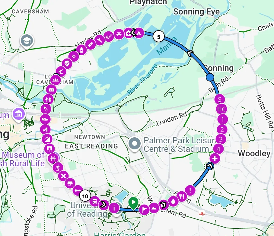
2. Names, shared spots and a point off the track
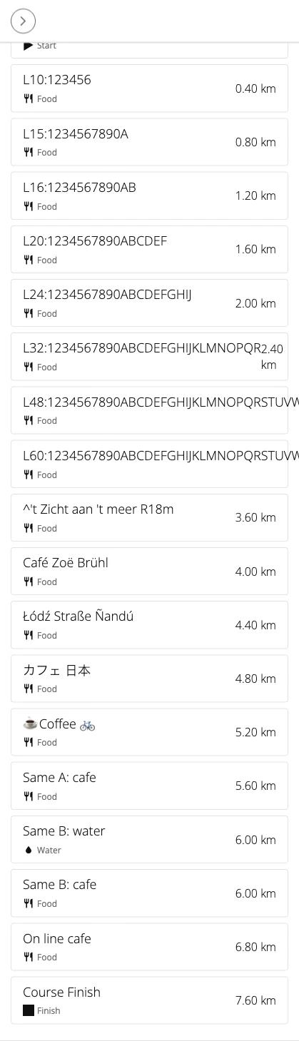
A 7.6 km loop with 19 points. The long names run 1234567890ABC... after their length, so the last character
shown is where the name was cut.

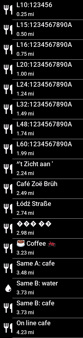
| Point | Garmin Connect | Edge 1040 |
|---|---|---|
| L10 to L60: names of 10 to 60 characters | Whole | Cut at 15: L60:1234567890A |
^'t Zicht aan 't meer R18m | Whole | ^'t Zicht aan ' |
Café Zoë Brühl (14 characters, 17 bytes) | Whole | Café Zoë Brüh (13 characters, 16 bytes) |
Łódź Straße Ñandú | Whole | Łódź Straße |
カフェ 日本 | Shown | ��� �� |
☕ Coffee 🚲 | Shown | Shown, in colour |
| A right turn and a cafe at one spot | Cafe listed, the turn not | Cafe listed, the turn not |
| A cafe and water at one spot | Both, at 6.00 km | Both, at 3.73 mi |
| A cafe 150 m off the track | Dropped | Dropped |
| A cafe on the track | Listed | Listed |
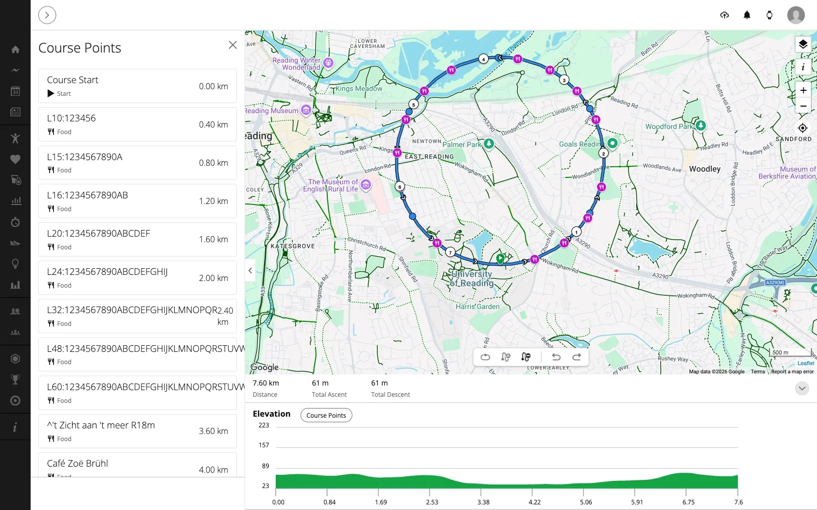
3. Out and back: Garmin Connect moves the stops
A 10 km course: 5 km east along a straight line and back the same way, with ten cafes on the way out ("Out 0.5km" to "Out 4.8km") and ten water stops on the way back ("Back 5.2km" to "Back 9.5km"), each named by its distance along the course and written at that distance in the file.
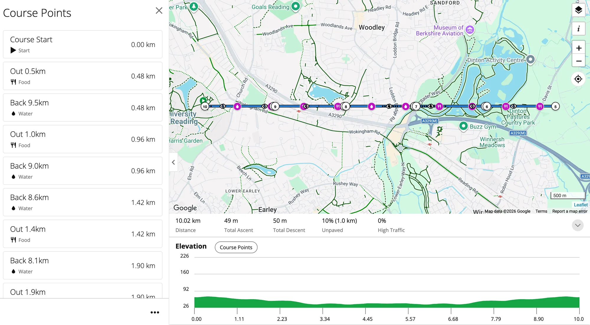
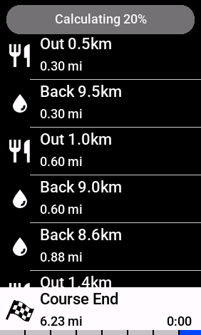
The same course on the Edge 1040, sent from Connect: the same pairs, and Course End shows 0:00, as Connect dropped the times.
Copied straight onto the device
The same file, copied over USB into the Edge's Garmin/NewFiles folder, without Garmin Connect:
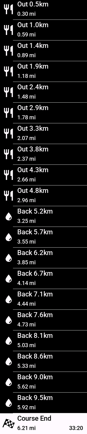
Every stop in order: Out 0.30 to 2.96 mi, then Back 3.25 to 5.92 mi, and Course End keeps the course's time, 33:20 (10 km at the file's 18 km/h).
So the device follows the file. It is Garmin Connect that re-places the course points and drops the times.
Two lines a few metres apart
The two directions of a real road, or a recorded track, are rarely one line. The same course with the way back moved to one side, the water stops on that line:
| Way back to one side by | Return stops in Garmin Connect |
|---|---|
| 0 m (one line) | All ten at the way out |
| 8 m | Nine right, one ("Back 7.1km") at the way out |
| 15 m | All right |
| 25 m | All right |
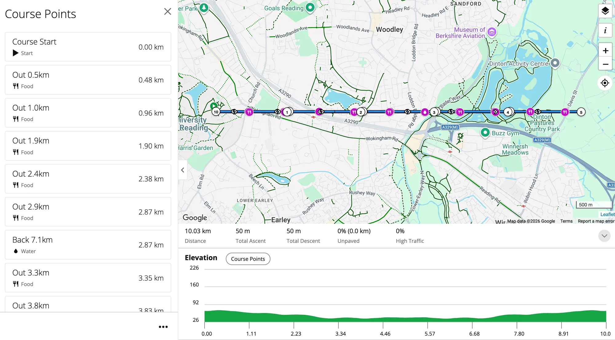
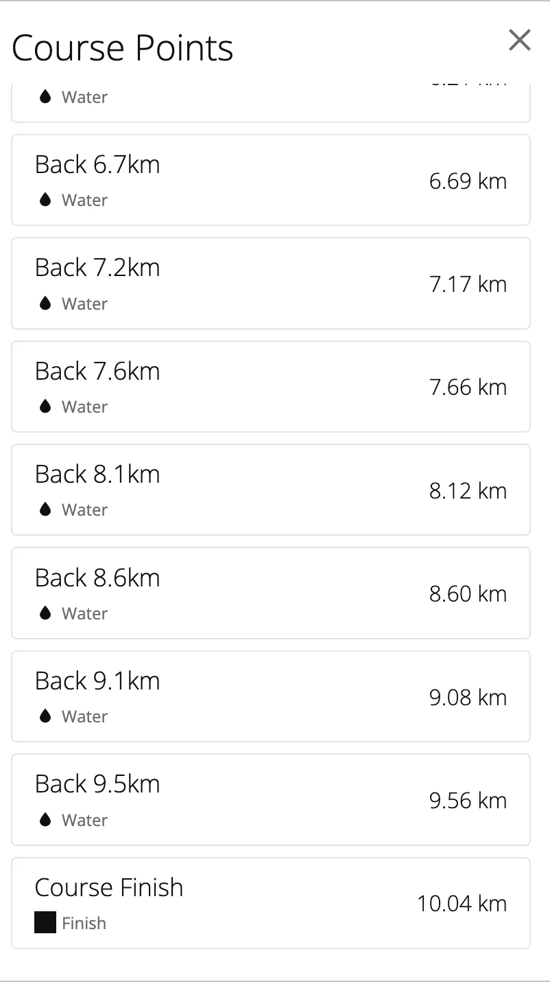
Garmin Connect puts each point on the nearest stretch of track, and where two stretches are as near, on the first. Moving a point off a road ridden twice does not help: it is then as far from both passes.
4. How many course points?
Edge computers were long said to stop at 200 course points, with the turns counting towards them (Edge 530), and Garmin began lifting the limit in 2023, on watches first (DC Rainmaker). Garmin Connect took a course of 300 and one of 1000, the second spelling the word with its points:
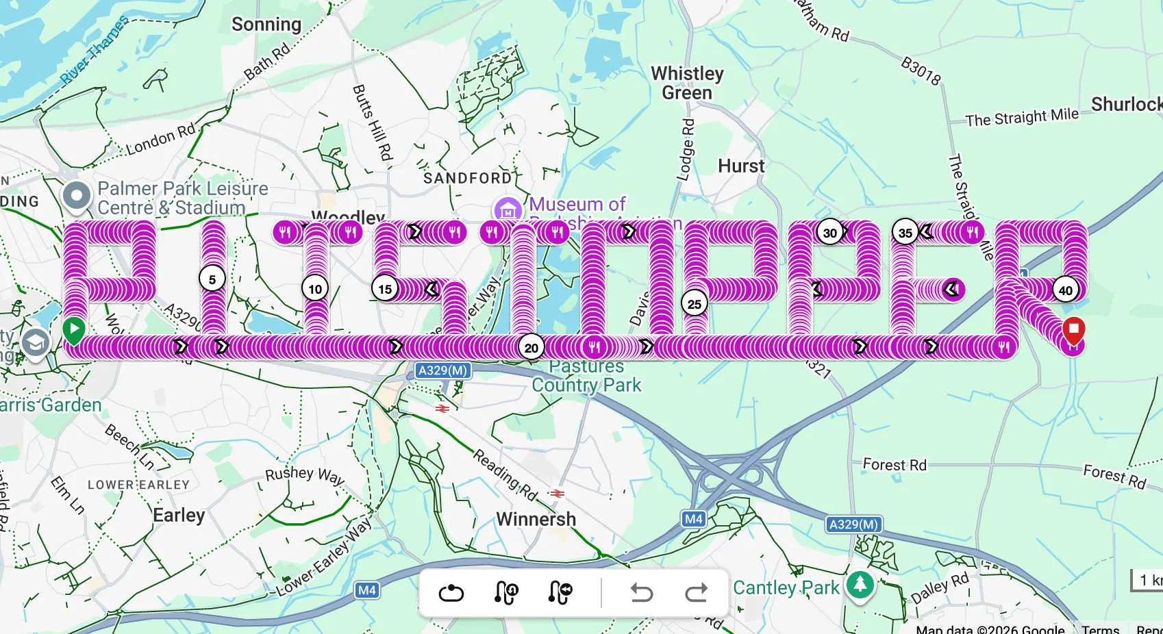
The Edge 1040 struggled with the 1000 and listed them out of order. The word's strokes go back over themselves, so that is the out-and-back above again; its own limit is still to be found with a course that does not cross itself.
Notes for developers
- The type is an enum. Write it with the SDK's name (
'food') or its number; there is no text and so no case. - Keep names to 15 characters, and count bytes, not characters, for anything with accents: about 16 bytes of UTF-8 survive on an Edge 1040. Avoid scripts the device has no font for.
- Put every course point within about 40 m of the track. Further off and Garmin drops it silently. Snap off-route stops onto the line and say how far off they were in the name or your own notes.
- Directions do not appear as course points in the list. If a turn and a stop share a spot, write two course points: the stop is listed, the turn is drawn as an arrow.
- On the device, the list follows the
distancefield. Two points at the same distance are both kept. - Garmin Connect does not. It works out each point's distance again from where it lies on the track, the first pass winning, and drops the course's times. For a course that rides a road twice, tell users to copy the .fit into
Garmin/NewFilesover USB. - Message order in our files: FileId, Course, Lap, Event (timer start), Records, CoursePoints, Event (timer stop). Positions are in semicircles: degrees × 231 / 180.
A course point with Garmin's JavaScript FIT SDK
import { Encoder, Profile } from '@garmin/fitsdk';

const semi = (deg) => Math.round(deg * 2 ** 31 / 180);
const e = new Encoder();
e.onMesg(Profile.MesgNum.FILE_ID, { type: 'course', manufacturer: 'development', product: 0, timeCreated: start, serialNumber: 1 });
e.onMesg(Profile.MesgNum.COURSE, { name: 'My course', sport: 'cycling' });
// ... a LAP, a timer-start EVENT and one RECORD per track point (position, distance, timestamp) ...
e.onMesg(Profile.MesgNum.COURSE_POINT, {
  timestamp: when, positionLat: semi(lat), positionLong: semi(lon),
  distance: metresAlongTrack, type: 'food', name: 'Cafe Zoe',
});
// ... a timer-stop EVENT ...
const bytes = e.close();   // a Uint8Array: save it as a .fit file
Not tested yet
- The alerts while riding: how early a course point is announced, and which one wins at a shared spot.
- The Edge 1040's own course point limit, on a course that does not cross itself.
- Whether Garmin reads a GPX waypoint's
<type>(FOOD,food,Food) when a GPX course is imported. - Other Garmin models: the Edge 1040 is the only device tried so far.
From PitStopper, which writes these course points in its FIT and GPX exports.